Distance: 8 miles Time: 5:50 Elevation Gain: 3800ft
All photos
The Franconia Ridge Trail traverses the ridgeline of three 4000ft peaks, all above the treeline, providing some of the best views in New England. Personally, it is the most spectacular, challenging hike I've done yet.
 |
| Franconia Ridge Trail |
The classic ridgeline loop hike starts at the Lafayette Campground in the Franconia State Park just North of Lincoln. The Old Bridle Path climbs three miles to the Greenleaf Trail, which takes you to the top of Mt. Lafayette. From there you take the Franconia Ridge Trail over Mt. Lincoln and then to Little Haystack Mountain. You then take the Falling Waters Trail back down to the campground.
 |
| Admiring the view from Mt. Lincoln (I think) |
At the trail head were two women who were doing the above loop in reverse and suggested I do the same if I wished to avoid the steep rocky descents on the Falling Waters Trail. I was easily convinced, so I followed behind them.
 |
| Waterfall along the Falling Waters Trail |
The Falling Waters Trail is a maze of broad, steep rocks and stream crossings, following the ascent of a waterfall, shifting one side to the other with the trail designer's whim. The footing is tricky but manageable until I meet a possible spawn of yesterday's barrier rock and must climb or retreat (okay, it was a neonate, but still...). I had dropped the women hikers a while ago and the other groups I had passed were far back enough not to witness my embarrassing attempts over the rock.
 |
| Looking down on the evil rock |
To the right of the rock was a dead tree, which when tugged hard, nearly came down, but it was the only source of traction I could find. So I used it to get half way up the rock, hoping it wouldn't give out under my feet, but I was still a few inches from another tree that I would need to grab to get up the rest of the way. I jumped a little to reach it, missed, and slid back down the rock, bloodying my knee and scraping away skin. I tried again and got it, using all the strength in my feeble biceps to pull myself up the rest of the way.
 |
| Trail crosses the waterfall |
After a couple more stream crossings (one a full-fledged waterfall crossing), the waters fell back and the trail began to climb in earnest. It was still extremely rocky and required using hands some of the time, but my feet were dry. I was having a blast.
 |
| I see light! Approaching the end of the Falling Waters Trail |
But all good things must come to an end, and sometimes something even better succeeds it. In this case, about 5000 feet better. I knew I was nearing the end of the Falling Waters Trail and approaching the first summit because I saw light coming from above, but the trail kept climbing and climbing.
 |
| Almost to the first summit! |
When I was able to finally stick my ahead out of the trees, what I saw and felt was a shock. After hours in the forest with little clue about what existed around me I was presented with the pile of steep rocks that is Little Haystack Mountain, and 25-30 mile per hour sustained winds.
 |
| Someone emerging from the Falling Waters Trail |
 |
| From Little Haystack Mountain, 4800 ft. |
From there it was just a short climb to the top at 4800ft, but I was so giddy it make the trek difficult. Also the wind gusts required that I stay close to the ground lest I get knocked right off.
When I finally made it, I found several groups of people nestled in the nooks on the other side trying to escape the wind. I just wanted to stand on top and absorb it. Immediately my hands were freezing. With the wind chill it was about 45 degrees but it felt much colder. Strangely nothing else felt cold, even though I was wearing shorts.
 |
| Climbing one of the other peaks |
Next was Mt. Lincoln at 5089ft, then Mt. Lafayette at 5259ft. Climbing up and down these peaks along the ridgeline was completely ridiculous. Stunning, amazing, but crazy. The wind gusts had to top 40-50mph, and catching one at the wrong time could send you plunging off into the valley. Holy crap was it great though!
 |
| Top of Mt. Lafayette (5259ft) |
Climbing down Mt. Lafayette was not as great. It was pretty scary at times near the top where the wind was still gusting heartily and I was trying to not fall down the long cascade of rocks that sweeps you to the bottom.
 |
| I could really use a sled here |
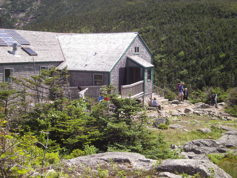
At the bottom of Mt. Lafayette, before starting the final descent is an AMC hut -- I finally get to see one! This one is immaculate with clean bathrooms, free coffee, a full kitchen and rooms of bunk-cots for overnighters.
 |
| AMC Hut |
The top stretch of the Old Bridle Trail is just as rocky and difficult as the previous trails and my feet are killing me. It's definitely not an improvement over the Falling Waters Trail as I had been instructed. After about a mile; however, the trail smooths out a bit and by the last mile it's nothing more than a nice stroll through the woods. Thank you Sue.
 |
| I was just up there! Looking up at the Franconia Ridge Trail from Old Bridle Path |


No comments:
Post a Comment