Sunday, May 29, 2011

Colbert Ridge Trail & Deep Gap Trail

Miles: 10.12   Time: 5:49  Starting Elevation 2806ft   Elevation Gain: 3777ft

View all photos of Colbert Ridge Trail     View all photos of Deep Gap Trail

The past two and a half months of physical and emotional experiences on the trails of North Carolina coalesced today in the hike that will crown my time here before leaving for New Hampshire next weekend. The Colbert Ridge Trail begins a few miles North and a hundred feet lower than the trail head for the Mt. Mitchell Trail that starts at Black Mountain Campground, which I did a month ago. If you recall, the Mt. Mitchell Trail climbs 3600 ft to Mt. Mitchell, the highest point East of the Mississippi.

8:30am on the Colbert Ridge Trail -- I love the mountains in the morning!

The Colbert Ridge Trail is a 4 mile trail that ends at the Deep Gap Trail, also known as the Black Mountain Crest Trail, which is considered one of the most rugged trails in North Carolina and the East. The Colbert Ridge Trail climbs steadily from the beginning and steeply for much of it. So steeply, it felt a bit like interval training: climb for a quarter mile, and just when you're almost out of breath the trail levels enough for you to recover for 2-3 minutes before starting again.

Other side of the trail, a few hundred feet up

The first 2.5 miles was technically easy with only a few patches of roots, erosion and boulders, allowing for some very aerobic climbing but then it turned into a obstacle course where very careful footing was required. It continued this way to the top, and was good practice for the Deep Gap Trail to come. When I arrived in NC, such impediments would have driven me nuts; I wanted to climb uphill without a break in my heart rate, but now it was just fun.

Camping area at Deep Gap


The trail ends in a camping area and when I arrived around 9:30 the backpackers were just rolling out of their tents. I'm getting the impression that many hikers are pretty lazy. Most of my encounters with backpackers have been similar: day one, hike three hours, camp, return next day. It takes two days to hike six hours? What do they do with the remaining 12 hours (besides sleep)?

From Balsam Cone Peak on Deep Gap Trail (6596 ft)


I had intended to hike only the Colbert Ridge Trail today, and then some easy trails with Katie, but since it took only two hours to climb, was only 9:30, I went on. One of the backpackers showed me his map and said I could go East for 10 minutes or West for 30 minutes to see some views. West was Mt. Mitchell so that is where I went.

Looking West from Deep Gap Trail toward Mt. Mitchell
The backpacker said it took three hours to hike from Mt. Mitchell to Deep Gap, so if I hiked to Mt. Mitchell and back it would be about a 10-hour day on some of the most rugged trails in North Carolina and beyond.  The idea was alluring. The trails got tougher than Colbert Ridge, but because it was a crest trail, it climbed up and down the peaks instead of relentless ascension.

Looking East from Deep Gap Trail toward Winter Star (I think)
Deep Gap sits at about 5600 ft and climbing upward from it you pass through a Canadian ecosystem of evergreen forests: it smells like a Christmas tree lot, and it's amazing! The trail passes four 6000ft + peaks over about four miles or so and I made it through two of them before I decided to turn around (Balsam Cone and Cattail Peak).

Looking North or South from Deep Gap Trail (I don't remember which)
I was tired. My legs were tired. And climbing downhill is hard enough without adding shaky muscles to the mix. I considered hiking to Mt. Mitchell and catching a cab back to my truck, but I don't think I can get cell service there. Also, it felt like cheating. Even though the distance would not be any shorter than my planned hike for the day, there is something rewarding about arriving at your car on foot.

Tired! Time to go home.
I expected the return to be a slow, agonizing nightmare of twisted ankles, butt slides and tumbling. I wasn't completely wrong -- my ankles weren't too happy, I fell on my ass a few times and slid down some rocks, but nothing that caused lasting pain or even verbal assault. My stabilizer muscles were finally adapting.

Katie enjoying the water


The Carolina Hemlock Recreation Area is nearby and I was sure I could find a short trail or two for Katie, though all I wanted to do is lay down in the bed of my truck and sleep. The area is composed of a large campground, a short trail, and a river runs through it (yes, that was on purpose). The South Toe River is lined with large boulders for sunbathing or jumping, and a couple sparsely sanded areas, mimicking a beach. It was perfect -- I relaxed on a rock in the sun while Katie splashed in the water.

Saturday, May 28, 2011

Looking Glass Rock


Driving along the Blue Ridge Parkway South of Asheville you can see a huge monolith protruding from the valley below. It's highly visible and catches your eye each time, and is a staple in Asheville photography. This is Looking Glass Rock. It's sheer granite face is popular among rock climbers, but you can also hike nearly halfway up the backside of the rock to the 4000ft summit for panoramic views of surrounding mountains.

Top-o-the-rock, looking at surrounding mountains

The trail head is located in Brevard, about 30 minutes South of Asheville in the Pisgah Forest. In fact the entire trail runs through the forest, steadily climbing 1649 feet for 2.7 miles. Near the top you see a large flat slab and some not-so-flat boulders (one of which I would attempt to climb), a portent of the nearing climax. The flat slab is actually a helipad and the start of a spur trail that leads to one face of the mountain.


At the end of the trail the forest stops and you walk out onto the rock, which is somewhat flat near the forest edge but quickly drops off into cliffs. I wouldn't want to be here after or during a rainfall or you could have a nice 4000ft slide.

As Steven Tyler would say ... Going dowwwwnnnn??

On the way back I took the spur trail through the helipad to the side of the rock for continuous views of the surrounding mountains.

From the spur trail
I also decided I couldn't pass this boulder without getting my hands on it. I'm not typically adventurous but what the hell.

I must climb!
I crawled up the side, where the forest meets the rock to that I would have some footing. Then I was able to reach some moss-covered portions that enabled me to get about halfway up. From there I could stand up and walk across a portion of it but I couldn't (or didn't want to) go any further so I slid back down on my butt and continued down the rest of the trail.

Side of the rock with some footing along the forest
Despite my late start this morning I made it through most of the trail before the Memorial Day mob rolled out of bed and got their act together. It only took about 2.5 hours though and I had no other trails planned for the day (one website advised leaving a 4-5 hour block of time open for this trail; they must have had a very long picnic at the top). The area was strewn with trails though so I drove around a little and found a short Katie-friendly waterfall trail.

Moore Cove Falls
But short family-friendly trails are becoming a source of extreme aggravation and I think this will be my last. After I had been working from home for awhile, my stress level had decreased so much that the standard intricacies of office communication created a level of stress I could no longer deal with. Such was the case now with the weaving children and the cooing adults and butt-sniffing dogs. I needed to exit this trail soon or I might jump into the stream to escape.


The end did not come soon enough but when it did I pulled Katie to the truck and drove up the mountain where earlier I had seen a sign for the Blue Ridge Parkway. I knew there I could find a quiet trail where I could be alone with the trees and hike in peace.

Monday, May 23, 2011

Linville Falls and Linville Gorge

Linville Falls is a town and a waterfall, about an hour Northeast of Old Fort. It is reportedly the most photographed waterfalls in North Carolina, though I thought Catawba Falls and Hickory Nut Falls were more impressive. Linville Gorge, however, earns its moniker as "Grand Canyon of North Carolina".

Linville Gorge, from Hawksbill Trail

Linville Gorge is one of the most rugged and scenic gorges in the Eastern US and is a designated wilderness area of North Carolina. Elevation ranges from 2000 feet at the Linville River to 4000 feet atop Hawksbill Mountain, which is the trail I started the day with.

Trailheads can be found on both sides of the Gorge, and Hawksbill is on the Eastern side a few miles down a bumpy, unpaved, gravel road. The vision of Linville Gorge in my mind was one of open grass, an amalgamation of the Shining Rock Wilderness Area (from two weeks ago) and what I can imagine the Grand Canyon might be like if it were green. But instead it is heavily forested (it is part of the Pisgah National Forest after all), and the perfectly clear, sunny day would go to waste.

Hawksbill Trail, starting to ascend

I didn't know much about the Hawksbill Trail before I started, well nothing really except that I was promised a nice view. For much of the beginning it was rocky and climbed very slowly, somewhat dull. Once it picked up though, the trail steeply ascended through a bright spot of sparse trees and my tummy warmed with exertion.

Pseudo-rock climbing
I had to tuck away my camera and water so I could use both hands to climb, clawing roots and mounting big boulders. During moments like these, I wonder what it must feel like to be a 12-year-old boy, when Twainian adventure is king (as an English major I reserve the right to make up words, especially when they relate to authors of classic literature).

Beautiful!
After a short while I saw a spur off to the left. I typically refrain from these but this one had bright light at the end so I naturally moved toward it. It was a good thing I did because it was the only breathtaking view I saw all day. It was, of course, the Linville Gorge, in its entirety and one of the most spectacular things I've seen so far.
Steeper than it looks here --  had to turn around

I continued along the trail and it soon became nearly unclimbable. The slope had roots for footing and handling, but it was at such a grade I was sliding a bit with every step. The trail is unmarked, but I never saw an alternative path that looked viable. This had to be it (I think) but I just couldn't do it. Visions of broken body parts danced in my brain so I slid back down on my butt.

Runners feel great shame in uncompleted runs and races. We will slog along so slowly that we might as well be walking, but we will not quit. My runner brain was pissed off and ashamed, so I had to tell myself the rest of the way back that I was not on the trail, that I had missed a turn off somewhere. 

About half way down the return is a trail head for another trail, one that I didn't know anything about but decided to try it anyway. I had one more trail planned before heading over to Linville Falls, but I had plenty of time. The trail descended down the Gorge, and it quickly grew dull. All down, all trees. Of course I knew I had a nice climb ahead of me, but since there could be no rewarding views at the bottom, I was getting impatient. A hiker passed from the other direction and assured me it was worth the time, so I continued. Down, down, down. After a mile I turned around. So far I was 0-2, not a good day.

The climb back up the Gorge was a mile straight uphill, at a decent grade, which I didn't realize on the way down because it was pretty easy. By the time I reached the top I was drenched in sweat, from hair to shorts. If nothing else, I had a good workout this morning.

When I returned to the parking lot, three guys I had passed on the way down the Gorge were chatting. When I told them I didn't make it all the way down, they said I missed a stunning view (of what?). They also assured me I missed the climax of the Hawksbill Trail, a rock with 360 degree views.

After driving another five miles down the unpaved road at 15-20 miles per hour I couldn't find the second trailhead and my frustration grew after a near-collision on the single-lane road. Screw it, I turned around and drove back to the Linville Falls parking area to begin the second half of the day.

Linville Falls


At this point I was tired and agitated. I knew the trails at the Falls would be easy and crowded but the people were driving me nuts anyway. Having Katie along can be a mixed bag of companionship from her and fellow hikers, the latter of which can be tiresome. The thing about a beagle is that everybody has one or had one and they make sure to tell you about it. And children, as cute as they can be, must pet every dog they see. This process can lengthen a hike by 50%.

Me & Katie at the Upper Falls

To pile it on, the trails were merely wood-chip sidewalks and still people complained about how much walking they had to do. One man decided he would sit in the car and wait for his family before seeing anything more than the restrooms, and I silently applauded him. A great thing about being alone is that you can leave whenever you want, and I wanted.

Lower Falls

Friday, May 20, 2011

Chimney Rock and Lake Lure


Chimney Rock and Lake Lure are neighboring resort towns 20 miles South of Black Mountain. I passed thru both on the way to Black Mountain from Florida. It was my first experience in the Mountains, driving up Route 9, which winds slowly up through the mountains from South Carolina and ends at Montreat (next to Black Mountain).

One face of Chimney Rock, from the lower parking lot
I fell in love with these towns immediately and thought it might be worth while to spend a week there prior to leaving Asheville, but instead opted for a Friday afternoon. I have only two weekends left in Asheville and one of those is Memorial Day so I thought I had better get the tourist attractions out of the way.

The Chimney, as seen from a trail above it
Chimney Rock is named for Chimney Rock (no!), a 315-foot, 535-million-year-old monolith that is the center of Chimney Rock State Park.  To reach the top you drive a couple miles up the mountain until you're almost at the top, and then you can hike the rest of the way (what a jip...).

On the Chimney

The highest point of Chimney Rock is Exclamation Point (isn't that the best name!) at 2,480 feet, and just below that is the Chimney, an outcrop that serves as the focal point of Chimney Rock and where most tourists arrive by elevator. You can also climb to the Chimney and then on to Exclamation Point via 470 steps, which today I had to share since the elevator was undergoing renovation (though I did save $2 on admission!).

Exclamation that's a good view! Hickory Nut Gorge from Exclamation Point


Katie made it up about five steps before she stopped to rest, so I thought she would be more comfortable in the truck. Most of the people on the stairs would have been as well, and made sure everyone knew it.

Hickory Nut Falls
The next trail is the Hickory Nut Falls trail, leading to ... Hickory Nut Falls. (I really dig the practical naming schemes here.) It's an easy 3/4 mile to the falls, rounding the huge rock-faced mountain side and peering down in the gorge.

Looking up!
The last trail is the Four Seasons Trail that leads through the woods from the upper parking lot to the lower. It's a little over a mile round trip and has some steep sections which are nice. This is the first time I'm climbing down the mountain and then back up, and this works so much better!

Lake Lure, from the beach
 Next is Lake Lure, a beautiful resort town shouldered up against Chimney Rock Village. My favorite film of all time, Dirty Dancing, was shot here, so I was anxious to find some visual clues. I parked in the municipal marina and community center parking lot, which provides access to the the park trails around the lake. These are just walking trails, and are perfect for Katie.

Lake Lure Beach
We toiled along the lake for about an hour, but Patrick Swayze's cabin was no where in sight ...

View of Lake Lure from the top of Chimney Rock

Sunday, May 8, 2011

Black Balsam Knob

Miles: 12
Time: 6.5 hours
Elevation Gain: Roughly 1500 feet?

(I made the mistake of using my GPS running watch on Mt. Mitchell last week and now my compulsion to record has been extended to hiking. Although, now I need a watch that records elevation as well.)

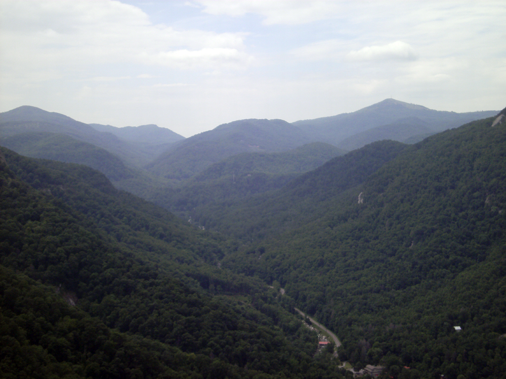
Morning view from the top of Black Balsam Knob

I have given my heart to Art Loeb and his trail, section 3, or some of it at least. Shining rock and its evil spawn of rocks, he can keep.

The open balds offer persistent views

The Art Loeb Trail spans 30 miles and is divided into four sections. Section 3 begins at the base of Black Balsam Knob and crosses four peaks over 6000 feet: Black Balsam Knob (6214 feet), Tennant Mountain (6040 feet), Grassy Cove Top (6050 feet), through the Shining Rock Wilderness and over Shining Rock Mountain (6000 feet), and then past the base of Cold Mountain (yes, the one from the novel and film). Each ascension is not more than a few hundred feet, so elevation gain is minimal despite the number of peaks. (Art Loeb was a Carolina Mountain Club member who often hiked and cared for the area.)

From the start of the trail, looking back over the mountains I drove up through

What makes this trail spectacular is the bald, treeless ridgeline of the mountains it crosses. On a clear day, like today, the visibility can reach 70 miles. It is stunning, unbelievable that I have lived 35 years and not hiked this trail. Mt. Mitchell may own the best single viewpoint at 6684 feet and offer a more strenuous climb, but I will take the balds. Maybe it's the innate sun-worshiper in me or my fear of whatever wildlife is always rustling in the forested trails, but as the lean morning sun climbs over these mountains there isn't another place in the world I would rather be.

The first "bald" before Black Balsam Knob

It was another perfect Saturday for hiking in Western North Carolina. I couldn't believe my luck to have two Saturdays like this in a row: 40 degrees in the morning, rising to 60 or so in the afternoon under perfectly clear skies. The trail head is located off the Blue Ridge Parkway, about 35 miles South of Asheville (nearly 1.5 hours from Old Fort).

A rocky ascent up the second bald


At the start of the trail, some backpackers are just waking up from their overnight in a forested area to the right. Then the trail ascends the first "bald", exposing the beautiful mountain views I passed on the drive up the Parkway. I have never seen anything like this before; it seems like it belongs in another country. When I have imagined hiking mountains, this is what I pictured. Not forests, but open areas of grass and rock.

They have the right idea: Camping at the top of Black Balsam Knob

After another small bald is Black Balsam Knob, the peak of the trail in terms of height and views. Climbing up I see a tent at the top, and I can't think of a better place for it. In fact, farther down the trail are several camping areas and several campers, none who thought the highest peak on the trail might be the most spectacular. 

From the top of Black Balsam Knob

I wandered around the peak of Black Balsam Knob and found a meandering trail around the side. It wasn't marked but it was obviously going in the right direction so I followed it down through the open grass, frolicking like a 12 year old Swiss girl. Up the next mountain I climbed and came upon a backpacker, still exhausted from an eight mile hike the day before, but determined to make it through another one today.

On the way up Tennant Mountain
The backpacker told me to pass, but I was busy taking pictures, wanted to go slow because of my ankle and wanted to follow him since he was doing a loop I had read about but couldn't find enough information on to try.  So I stayed back and followed him.

From the top of Tennant Mountain
At the bottom of Tennant Mountain is an open area for camping with abandoned campfires, and from there you enter the Shining Rock Wilderness area.

From the bottom of Tennant Mountain
At this point, there's a fork in the trail, and the backpacker ahead of me goes right. This path looks less frequently traveled but I followed him because I was interested in doing the loop. Also, the other trail looks like it's bypassing the mountain, whereas this one is definitely going over the top.

Ascending Grassy Cove Top


Near the top, the trail winds around the side and eventually I come across the backpacker resting, so I passed. I never saw him again.

From Grassy Cove Top
At the bottom of this mountain you enter the Shining Rock Wilderness Area, a 18,483 acre tract of preserve known for its huge, white, quartz rock outcrops at the peak of Shining Rock Mountain.  It's also known for its poorly marked trails, which I would soon discover.

Approaching Shining Rock Mountain
At the foot of Shining Rock is another camping area, this one populated with a few tents and some college students. They are just getting started, and jump out onto the trail ahead of me. I followed them for awhile until they, too, stopped for a break. It's not a long break though, as I hear them behind me as I continue on.

The pile of rocks I decided was the trail
I arrived at a wooded area with no indication of where the trail leads. A huge, monster rock lies to the left, and no trails are visible. For some reason, I gravitated to the rock instead of the other peripheries and started climbing it. It looked sort of like a trail, and then I heard one of the students close behind so I thought maybe it was. I don't usually take joy in this sort of thing, but I was climbing a rock! I felt like a child and it was fun.

Shining Rock. I was standing on it, so hard to get a pic.
Only one person followed, and I learned from him that it was not in fact the trail, but this was Shining Rock and we were standing on it. His friends had climbed onto it from some other direction and they delighted in getting a new photo for their Facebook page. I felt about a hundred years old. The guy who had climbed up behind me had a map and showed me that we were on Shining Rock Mountain, and if we climbed down the other side it would meet back up with the Art Loeb Trail, which led to Cold Mountain.

Another hiker enjoying the view

I didn't want to wait for the boys so I climbed down the rock, figuring I could find the trail off the mountain, and reconnect with Mr. Loeb and his trail. I couldn't and I didn't. After dismounting the rock, I saw nothing that resembled a coherent trail, but a path or two that looked promising. It was all large boulders and treacherous trails that stopped immediately against impassable bush.

Climbing off the rock down some rocks that I thought might be a trail
I heard the boys head off in another direction and tried to follow but I was too far away and couldn't find a direct path from where I was. I climbed back up the rocks but by then they were gone and I had no idea what direction they went.  Every trail I took led to some shining rock or another, but not the one I started from.
Another dead end, but at least there's a nice view!

I started to panic. I tried one dead-end trail after another until I came to a wooded camping area that had several trails leading out from it. One of these must lead to the actual trail. I tried each one until I found what appeared to be a legitimate trail and followed it in the direction that would have put me back on track to go over the Shining Rock mountain in the direction the boys had gone.

By now though, I had no interest in seeing anything new; I wanted familiar. I had been hiking 3.5 hours, so I still had a half hour before my planned turnaround, but I really just wanted to head back. Shortly I came across a group of hikers and asked them what trail we were on, and they were just as lost as I was. They, too, had been to Shining Rock and now were trying to get over the current mountain, and on to Cold Mountain. I told them I thought they were headed in the right direction and continued backtracking.

The other fork: a semi-forested path
I came to a fork in the trail that I ignored before since I was following the backpacker. I had some time to spare so I took the opposite path, hoping it was just another way to get around the mountain and to see something new. This trail rounded the outside of the woods that topped this mountain, whereas the other side was open. After about ten minutes I heard some rustling in the woods above. This wasn't unusual of course, but I looked up to see a large cat-like form darting through the trees.

Reminds me of a dehydrated Everglades
Trails in the area are often posted with instructions for bear encounters, but what about mountain lions or similar creatures? Do they even exist here? Maybe it was a deer? I stopped, then quickly turned around. They say you should were bells or sing to avoid startling bears so I started singing refrains of "la la la", hoping the same applied to whatever this creature was. I repeated the "song" over and over and over until I emerged from the forest and rejoined the original trail.


I loved balds more than ever, and hiked around the other side of the mountain as swiftly as I could to reach the portion of the trail that descended down. There I encountered yet another fork, and since I couldn't remember how I came up I chose one and down I went, stumbling over a litter of descendant shining rocks. I didn't remember the trail being so rocky on the way up, but my memory has failed in greater matters than this.

Then it finally came, the ankle twist I had been waiting for, and a shriek followed that must have filled the valley below.  The pain dulled after a minute or so and when I tested my foot I found it unaffected. Just my ankle was sore so I moved on down the rocky chute, stone by stone, until I reached a connecting trail and a sign that said, "Erosion", indicating the direction from which I had come. I now remember this sign and this junction, naturally following a different path up the mountain. Argggghhh.

Finally off Shining Rock -- Time to pee!
Leaving Shining Rock, I was now ready to resume my pleasant journey back through the balds, but first I had to pee. I had been thinking about how this would go, since there are no trees to duck behind, and was going to do it on the semi-forested spur until wildlife threatened it right out of me. Now, in an open valley between mountains it seemed natural to leave the trail and find a comfy patch of grass, which was indeed an improvement over any forested trail I've used before. I do love it here.

A nice break for my ankle
 At the base of Grassy Cove Top there's another unmarked fork, but this time I remember which one I came down and that it was the correct trail. However, the other trail was wide, clear and flat and looked like it was going around the mountain. With my ankle still reeling from the erosion on Shining Rock, I decided to follow it. It was the reprieve that I needed and indeed it joined the trail again on the other side.

Climbing up the other side of Tennant Mountain

One of the best things about this trail is that the return trip is just as fun as the way out. Since it climbs up and down a series of mountains, you're climbing the portions you walked down before, and vice versa, and it seems like a completely different trail.

A couple enjoying the view on Tennant Mountain


With the ankle now turned once it was sensitive to every slight twist and the remainder of the trail seemed like a rock quarry. The other ankle could turn 90 degrees without any twinge of pain, but the other reveled in it. So, despite my love for Art, I was quite happy to see him end.

One last look from Balsam Knob before heading back